Why is there a “vestigal” stoplight just south of Clark/Roosevelt?

[flickr]photo:6967529270[/flickr]

Although it’s hard to see, there’s a button-activated, signalized crosswalk located between the first planter median and the jersey wall.

[This piece also runs in Time Out Chicago magazine.]

Q: There’s a working stoplight on Clark south of Roosevelt, that doesn’t seem to have any purpose or function. What’s the deal with this vestigial traffic light?

A: The Chicago Department of Transportation (CDOT) installed this signal during the 2004 rehab of the Clark/Roosevelt intersection, when the Clark underpass was built, says spokesman Pete Scales. The stoplight was included for a future access road to a housing development planned for the vacant land southwest of the intersection. “That massive redevelopment project never got off the ground,” Scales says. “At this point it might take more money to remove the stoplight than leave it in.” Continue reading Why is there a “vestigal” stoplight just south of Clark/Roosevelt?
CDOT installs new bike parking at six CTA and Metra stations

[flickr]photo:7114897063[/flickr]

Bike parking for more than 40 bicycles at the 57th Street entrance to the 55th-56th-57th Street Metra station. 

CDOT installed in March and April  a combination of regular u-racks and double deck bike racks at six CTA and Metra stations around the city and will hold a press conference at the 95th Red Line station today at noon. The coolest part of the project, in my humble opinion, is that I got to analyze and recommend the stations that would receive new bike parking. The bike racks are installed at the following stations, all sheltered, from north to south:

  • Howard Red Line – Rogers Park – Double deck
  • Loyola Red Line – Rogers Park – Double deck
  • Clybourn Metra – Bucktown – U-racks
  • Western Orange Line – Brighton Park – Double deck
  • 55th-56th-57th Street Metra – Hyde Park – U-racks
  • 95th Red Line – Roseland/Longwood Manor – Double deck

Continue reading CDOT installs new bike parking at six CTA and Metra stations

Confusing intersection of Milwaukee-Wood-Wolcott to be redesigned and reconstructed in Spring 2013 (was September)

Update September 7, 2012: From the Wicker Park-Bucktown SSA, we get news that this project has been pushed back to spring 2013. It seems IDOT is responsible for this delay. 

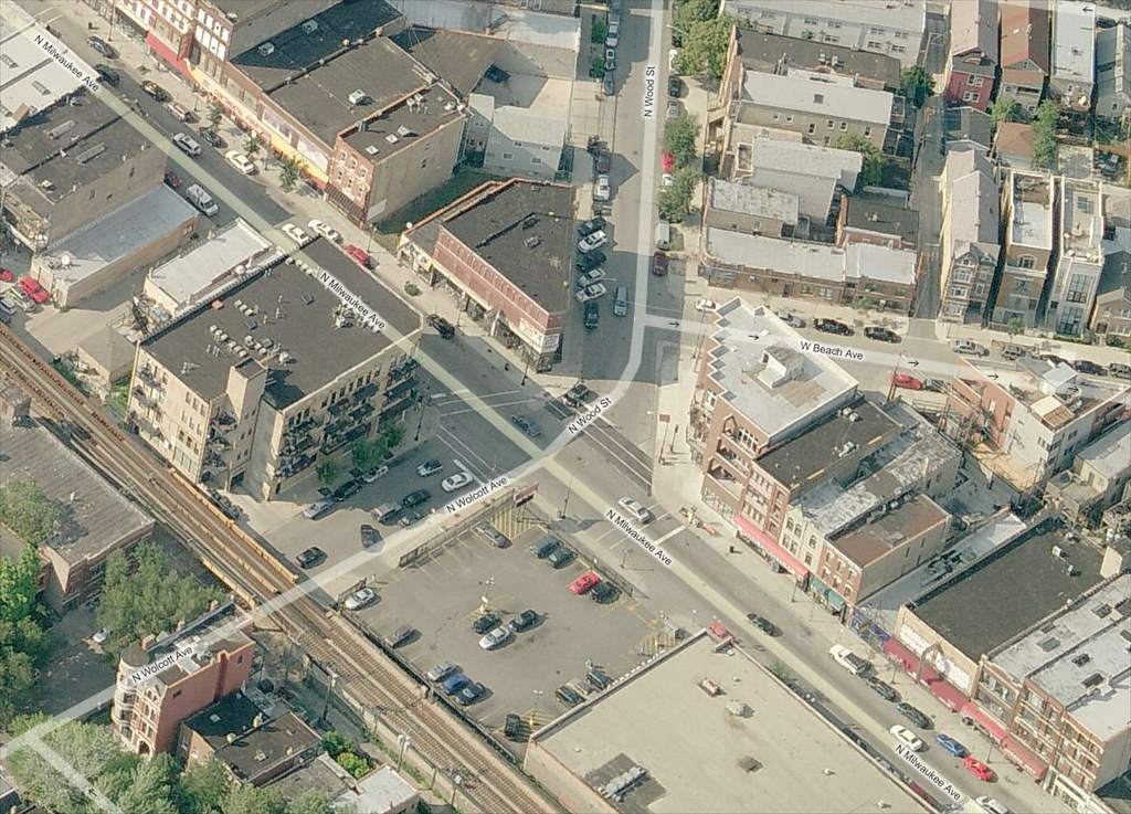
The skewed intersection of Milwaukee Avenue, Wood Street, and Wolcott Avenue in Wicker Park will be redesigned and reconstructed this year as part of a project to upgrade the signals. The original project only called for upgrading the traffic signals, which are decades old and very hard to see. Their timing is also awkward, providing no “all red” phase between the red phase of one direction and the following green phase of the cross direction. Construction should begin in September, according to the 1st Ward office.

Confusion is compounded with the addition of a rare slip lane on Wood Street at Milwaukee Avenue, which is created by a small island of concrete that only holds a light signal pole for southbound traffic. More often, islands are used to help protect pedestrians from traffic.

Bird's eye view of Milwaukee Wood Wolcott

View the intersection in a larger map on Bing Maps.

Continue reading Confusing intersection of Milwaukee-Wood-Wolcott to be redesigned and reconstructed in Spring 2013 (was September)

An extended LSD trip?

[flickr]photo:6961198870[/flickr]

McCaffery Interests rendering of the USX site, including a possible South Shore Drive reconfiguration.

[This piece also appeared in “Checkerboard City”, John’s weekly transportation column in Newcity magazine, which hits the streets on Wednesday evenings.]

Earlier this month Mayor Emanuel held a press conference at the former U.S. Steel South Works (USX) site, a weed-strewn piece of vacant land bigger than the central Loop, bulging into Lake Michigan from 79th to 92nd. He was there to herald the construction of a new $21 million, four-lane boulevard that will run two miles through the site, intended as the future main street of the proposed Chicago Lakeside Development.

Real estate developer McCaffery Interests hopes to build this upscale community with roughly 13,575 housing units, 17,500,000 square feet of retail and a 1,500-boat marina on the 589-acre site over the next few decades. “This [roadway] effort is part of a push to connect a forgotten, landlocked section of the Southeast Side of Chicago to the rest of the city, increasing its economic value,” Emanuel said. “What was once an eyesore will become an economic engine.”

Continue reading An extended LSD trip?

Fatality tracker update: four transit deaths, and 80% of pedestrian deaths this year are hit-and-run crashes

[flickr]photo:4036779679[/flickr]

The driver involved in the death of Martha Gonzales at 17th Place and Halsted Street has never been found. Quickly following the incident, Alderman Solis and the Chicago Department of Transportation implemented a few design interventions, including refreshed crosswalk markings, and a leading pedestrian interval that gets pedestrians crossing the street before drivers can start making turns. 

This is the second in a five part series on crash data analysis sponsored by Lawyer Jim Freeman.

2012 fatality stats*:
Pedestrian: 6 (5 have been from hit-and-run crashes)
Pedalcyclist: 0
Transit: 4

I made the Fatality Tracker because I want (need) to demonstrate that our roads are needlessly deadly. I’m not writing this to talk about how they may be dangerous. I don’t feel I can qualify or define that in a way that we’d all accept. So I’ll deal purely with specifics: how many people perished because our culture has an acceptable frequency of traffic deaths.

We report only deaths because of walking, cycling, or using transit. Why? Frankly, because tracking all traffic-related deaths would be too difficult to monitor accurately. I rely on newspaper reports, which don’t list all traffic deaths. If they were reported, the Fatality Tracker would be updated every 1-3 days.  Continue reading Fatality tracker update: four transit deaths, and 80% of pedestrian deaths this year are hit-and-run crashes

Grid Shots: Nature

Today is Earth Day. Although I’d argue that every day is earth day. The theme of today’s Grid Shots photo post is “nature”. When it comes to sustainable transportation, the most likely place you’ll discover the connection with nature is on a multi-use trail. And there’s where all of these photos were taken, by Joshua Koonce and Michelle Stenzel.

[flickr]photo:6946086386[/flickr]

Cycling on Northerly Island. This used to be an airport and runway called Meigs Field until former mayor Richard M. Daley sent work crews in the middle of the night to bulldoze X’s in the runway. The island (really a manmade peninsula) is now a bird sanctuary. Photo by MS.

[flickr]photo:7092155281[/flickr]

The Lakefront Trail is closed because of heavy wind and waves in October 2011. Photo by MS.

[flickr]photo:5659218974[/flickr]

People walk on the Bloomingdale Trail. Photo by JK.

[flickr]photo:5914551320[/flickr]

A guy rides his tricycle selling helado de coco, or coconut sorbet, in Humboldt Park. Photo by JK.